

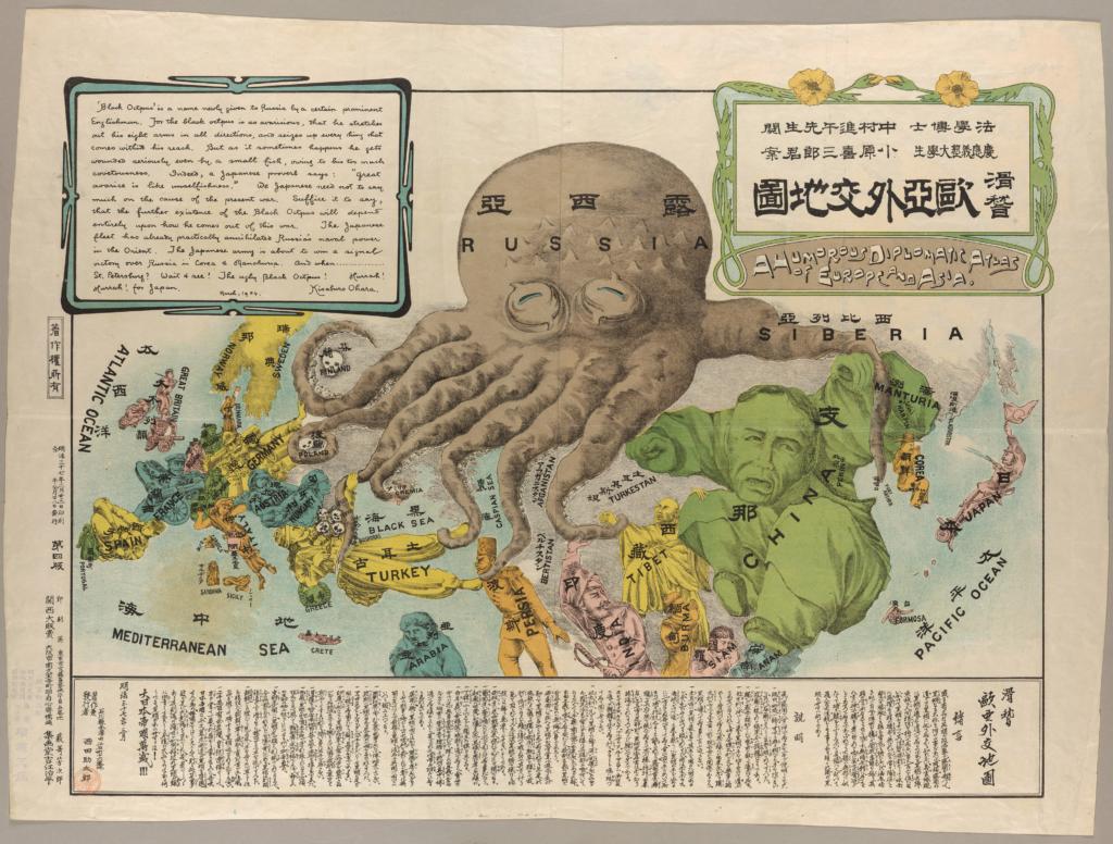
Throughout history, maps were usually used as a means of travel from point A to point B. However, in Kisaburo Ohara’s A Humorous Diplomatic Atlas of Europe and Asia, 1904 shows that maps can be used more than just for directions. Rather it can be used to represent early 20th-century geopolitics tensions in a “humorous” way. The map is illustrated to show a critical commentary on power, influence, and national identity during a period of political tension: the Russo-Japan War. Ohara’s map portrays European and Asian nations as exaggerated, caricatured figures creating a story situated through biases about envy, imperialism, and greedy motives instilled by Russia.
Looking closer at the map, one of the most striking features is Kisaburo Ohara’s decision to portray Russia not merely as a human caricature, like most other nations, but as a large, overbearing octopus. In political cartoons of the late 19th and early 20th centuries, the octopus represented entities perceived as greedy and oppressive, showing them as imperial powers, or threats. This imagery carries powerful hidden meanings as the octopus, with its many tentacles, symbolizes the far-reaching influence and control that Russia wants. Evoking fear, using the octopus as Russia’s caricature also emphasizes Russia’s aggressive attempts to exert control across Europe and Asia. In contrast, other countries on the map are represented as “regular people,” with exaggerated human traits that reflect stereotypes or national characteristics. For example, Japan is depicted as a small but confident figure, emphasizing its role as a rising power prepared to stand up to Russia’s overbearing influence. This contrast between the human-like caricatures and Russia’s dehumanized caricature underscores the map’s propagandistic message. Ohara’s choice of the octopus is deliberate as it visually encapsulates the idea of Russia as a predatory force with no moral restraint, positioning Japan as the defender against this large threat. This clever use of symbolic art subtly reinforces the narrative of good (Japan) versus evil (Russia) during the Russo-Japanese War, appealing to Japanese national pride and unity.
Additionally, looking at the size depiction of the caricatures, the octopus caricature magnifies Russia’s size and imposing presence in a way that conveys both its physical and political dominance over other nations. By positioning Russia as a heavy, dominating figure, with exaggerated proportions compared to the other smaller representations of other countries, Ohara emphasizes Russia’s perceived threat to the balance of power. The image of Russia hovering over its neighbors suggests an overwhelming, almost insatiable hunger for control, as if its mere proximity could capture these smaller countries into its sphere of influence with just a wrap of its sticky tentacles around it. This portrayal of Russia as a large oppressive force amplifies, again, the fear that its imperial ambitions could destabilize the region, and even the world.
Furthermore, around the areas gripped by the octopus’s looming tentacles, skulls punctuate the landscape, further amplifying the map’s anti-imperialist message. These skulls, stark symbols of death, destruction, and oppression, underscore the consequences of the octopus’s suffocating hold. By associating the octopus with such imagery, Ohara transforms it into a powerful metaphor for the devastation brought upon by Russian expansionism. This imagery also reflects Japan’s concern over Russian territorial ambitions, particularly in East Asia during the Russo-Japanese War because it highlights the fears of unchecked imperialism and symbolizes the danger of foreign domination, resonating with nations wary of losing sovereignty under the larger powers. By drawing the greedy tentacles around these skull markers in regions under Russian influence, Ohara emphasizes the political costs of imperialism, portraying it not as a gentle but a violent force visualizing the cost of expansion as devastation allowing for Ohara’s map to comment on its stance as a piece of anti-Russian propaganda and a broader critique of imperialist aggression.
Through the size and characters used to create Ohara’s map, it is evident that this piece was designed for purposes far beyond merely depicting geographical information. Instead, it functions primarily as a form of propaganda, employing artistic techniques and symbolism to convey political messages. J.B. Harley’s essay Text and Contexts in the Interpretation of Early Maps offers an insightful framework for understanding how maps can carry ideological meanings, transcending their role as mere navigational tools. In Text and the Context in the Interpretation of Early Maps by J.B. Harley, Harley suggests:
that all maps are rhetorical[…] because […] maps are never neutral or value-free or ever completely scientific. Each map argues its own particular case[…]They are part of a persuasive discourse, and they intend to convince. Theirs is not an innocent reality dictated by the intrinsic truth of the data; they are engaging in the ancient art of rhetoric. (Harley 37)
This quote from Harley emphasizes that maps are inherently subjective, shaped by the perspectives of their creators. When Harley says that “maps are never neutral or value-free or ever completely scientific,” he argues that every map is shaped and embedded with particular values. Ohara’s satirical map exemplifies this idea by distorting the traditional representation of geography through visual elements to communicate underlying political judgments about different nations. Just as Harley suggests that maps can reflect the biases and political agendas of their creators, Ohara’s map serves just that. An “accurate geographical map” is a visual critique of Russia’s imperialistic actions and a statement of Japan’s nationalistic pride, which reflects the biases of the mapmaker. The map, through its exaggerated portrayal of both countries and their moral standing, offers a clear commentary on the tensions of the Russo-Japanese War, aligning with Harley’s argument that maps are deeply embedded with the social and political ideologies of their time.
What Ohara is trying to depict is clear: Russia’s expansionism is not just territorial but also it seeks to engulf and dominate, erasing the independence of nations in its path. By drawing this comparison and using their bais to do this, ultimately, Ohara’s A Humorous Diplomatic Atlas is shown more than a satirical map, but rather an embodiment that uses caricature to critique Russia’s motives and greed for power. Applying J.B. Harley’s theory of maps as ideological texts allows us to see Ohara’s work as a layered commentary on Japan’s political stance. By interpreting Russia’s caricature through Harley’s framework, we uncover how Ohara critiques imperialism and elevates Japan’s position. This reveals not only the power of maps geographically but also ideologically in enabling the construction of identity, resistance, and power that reflects the cartographer’s vision and worldview.
Leave a Reply